
One of the benefits of re-organizing my photos on this site has been the ability to group them by something other than chronology. Many of my bird photos were captured in the vicinity of water, and looking at them geographically got me thinking about how the places I have visited intersect with the local watershed. To explore that idea further, here is a tour of the Tualatin River watershed, which drains much of the land west of where we live. I’ll consider watersheds to the east and north later.
The Tualatin River flows from the Tillamook State Forest on the eastern side of the coast range to the Willamette River, meeting it in West Linn, about 15 miles southeast of us. Its headwaters are in privately held forests and are not publicly accessible. Hikers in the 90s identified several waterfalls in its first dozen miles as it drops close to 2000 feet from the coast range to the valley below, where we know it as a slow meandering river. That’s where it gets its name, said to mean “Lazy River.”
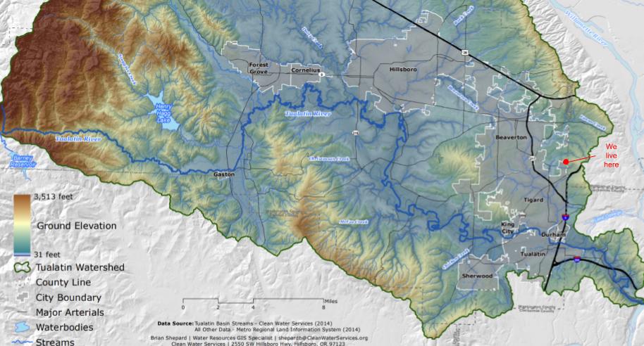
Here’s a map from the Tualatin River Watershed Council. Another great source for maps and other resources is the Tualatin Riverkeepers.
This watershed was originally populated by the Atfalati band of the Kalapuyas, the northernmost band of that tribe whose people lived in the Willamette River Valley. The Kalapuyas are now a part of the Confederated Tribes of Grand Ronde, which was created in the 1850s with the forced relocation of more than 30 tribes and bands to a single reservation in the southern Oregon coastal range. Tribal land allocations were reduced over the years, and Federal recognition for that group was stripped in 1954, and restored in 1983. I highly recommend the work of Stephanie Littlebird Fogel, whose installation “This IS Kalapuya Land” is currently at the Pittock Mansion in Washington Park. Her work expresses the history of the Kalapuya inhabitants of this land, as it also examines the way that history has been told.
Our house is on the western slope of the hills along the west side of the Willamette River. Our nearby hills rise to about 700 feet; we’re at 500, and the valley to the west is around 180 feet of elevation. Water flows into our backyard from the uphill neighbors, through our various drainage projects, and out into the street. We call this the south fork of Ash Creek, which isn’t accurate but seems appropriate to the amount of water that flows through each winter. From our street, the water continues down the hill into the city of Tigard.

Fanno Creek is the tributary of the Tualatin that drains our immediate watershed. With most of its route running through urban and suburban areas, Fanno Creek has had persistent problems with pollution. When we were house-hunting, we checked out a property right on Fanno Creek, and the attraction of “a creek running through it” was tempered by the view of discarded detritus upstream and downstream. Recent evaluations have described the water quality as poor but improving, due in large part to the creation of parks, natural areas, and urban wetlands, as well as improved water treatment and septic systems. We’ve played in many of the ~16 parks along Fanno Creek, and I’ve found waterfowl, kingfishers, sandpipers, and a wide variety of perching birds in or along the creek within just a few miles of home.


I have hiked and photographed many sites along the Tualatin and its tributaries. The western-most of my explorations was Hagg Lake, a reservoir on Scoggins Creek which is a tributary of the Tualatin, about 35 miles west of home. No photos from that trip, though. Following the river path towards the Willamette, I have visited Fernhill Wetlands (28 miles to the west) many times in different seasons. It is notable as a water treatment facility that converted its sewage ponds into a natural treatment system, improving the quality of the water entering the Tualatin as it provides a wetlands habitat for birds and wildlife.


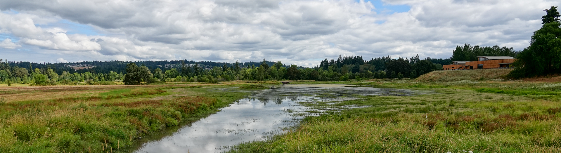
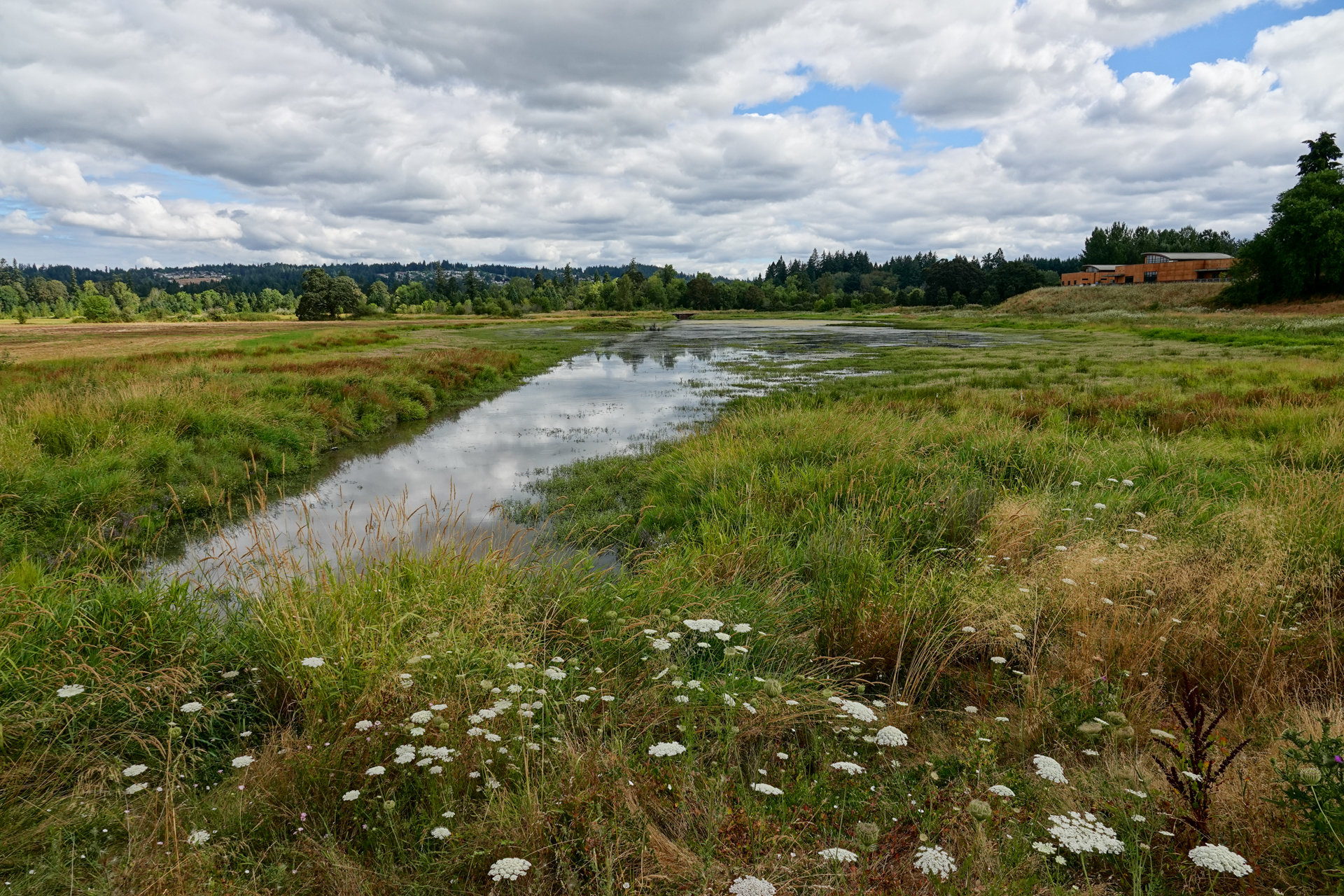
Continuing the river path towards the city of Hillsboro 19 miles west of home, I’ve made several visits to Jackson Bottom Wetlands Preserve. This site is the result of a project that began in the late 1930s, transforming a waste disposal site into an area of diverse habitats and hiking trails.


Another 4 miles downriver, we have visited Rood Bridge Park with the grandkids, enjoying the playground and trails. The park has a canoe and kayak rental and launch site run by the Tualatin Riverkeepers. That organization also has a similar operation at Cook Park 5 miles south of home, another park we have visited with the grandkids.
Between Rood Bridge and Cook Parks is the Tualatin River National Wildlife Refuge. This sanctuary has almost 2000 protected acres, with seasonal and year-round trails. At 8 miles to the southwest, it is the closest National Wildlife Refuge to home, and is one of my favorites. It is close enough to visit on a whim, and diverse and interesting enough to visit often. I have seen dozens of species of birds there; on one memorable visit, within the first few minutes I saw young swallows on a drainpipe being fed by both parents, and white pelicans swimming in the wetlands.


Other tributaries in the Tualatin River watershed have provided the occasion for hikes and birding. I have made repeat visits to the Tualatin Hills Nature Park, on Johnston Creek in Beaverton eight miles to our northwest. In addition to the trails, this park is well integrated with the surrounding community, with kids programs timed to match the flexible work schedules of local employers. A few blocks away, Johnston Creek connects with Beaverton Creek at the Beaverton Creek Wetlands, a small urban wetland accessed from the back end of an industrial parking lot.


Further west, we’ve also visited Orenco Woods on Rock Creek, which also flows into Beaverton Creek from the hills on the northern edge of the Tualatin River valley. I haven’t yet figured out how those creeks connect up to the Tualatin; once the creeks hit developments, they seem to disappear. I’ll try to explore that curiosity more in the future.
That’s the overview of our local watershed to the west and north, flowing into the Willamette River via the Tualatin River and its tributaries, and from the Willamette to the Columbia to the Pacific Ocean. Info about my explorations of the watershed flowing directly into the Willamette from the east and west, and into the Columbia from the north and south, will follow, eventually.
Leave a Reply